Isaias, After the Storm: About Six Inches of Rain, a Rocky Broad That Came Within 0.05 Foot of Major Flood Stage, and a Lake Now Refilling Toward Full Pond
Storm Coverage — Lake Lure, NC — Sunday night, October 11, 2026
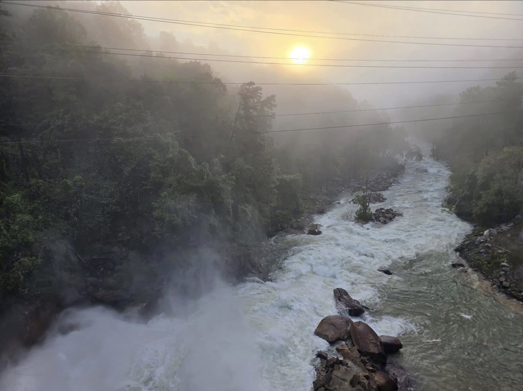
Photo: Lake Lure Insider and Rutherford County, NC Emergency Management
LAKE LURE, N.C. — The rain from Hurricane Isaias' remnants is over, the warnings have expired, and the rivers around Lake Lure are falling. The Rutherford County Airport in Rutherfordton recorded 6.11 inches of rain from Saturday morning to early Sunday, with nearly half of it in five hours Saturday evening. The Rocky Broad River at Bat Cave crested twice, the second time at 9.45 feet at 7:35 a.m. Sunday, 0.05 foot below its 9.5-foot major flood stage. By Sunday night the river was back below its action stage, and the lake was at 989.90 feet, about six-tenths of a foot below its 990.5-foot full pond and still rising.
This is our wrap-up of the storm. It uses gauge data through about 9:30 p.m. Sunday and rainfall reports available Sunday night. It does not try to count damage, because we do not have confirmed damage figures from the county or the Town. Our earlier coverage: Saturday night, Sunday morning, and what to expect.
How much rain fell
The National Weather Service had warned Friday evening that five to ten inches was possible along and near the Blue Ridge Escarpment by Sunday morning, and that five inches or more in similar storms has been associated with a higher risk of landslides. The measurements that came in fall inside that range.
| Where | Rain | What it covers |
|---|---|---|
| Rutherford County Airport, Rutherfordton (NWS/FAA station) | 6.11 in. | Saturday morning to about 5 a.m. Sunday |
| Volunteer station 1.8 mi. NNW of Bat Cave (CoCoRaHS) | 5.57 in. | 24 hours to about 7 a.m. Sunday |
| Volunteer station 0.4 mi. SW of Gerton (CoCoRaHS) | 5.34 in. | 24 hours to about 7 a.m. Sunday |
| Volunteer station 9.6 mi. ENE of Hendersonville (CoCoRaHS) | 5.08 in. | 24 hours to about 7 a.m. Sunday |
| Volunteer station 2.6 mi. WSW of Rutherfordton (CoCoRaHS) | 5.78 in. | 24 hours to about 7 a.m. Sunday |
| Volunteer stations near Old Fort, McDowell County (CoCoRaHS) | 7.70 to 7.72 in. | 24 hours to about 7 a.m. Sunday |
| McDowell County communities of Sugar Hill, Zion Hill and Crooked Creek | More than 7 in. | Overnight Saturday into Sunday, per NC Emergency Management as reported by Spectrum News |
| Asheville Regional Airport | 3.81 in. | Saturday only; a daily record, per the NWS |
| Greenville-Spartanburg International Airport | 3.12 in. | Saturday only; a daily record, per the NWS |
A few cautions. The volunteer numbers come from the Community Collaborative Rain, Hail and Snow Network and are unofficial. The airport figure is the sum of hourly readings, so it may differ slightly from the NWS's official daily totals. As of Sunday night we had not found a report from the volunteer stations nearest Lake Lure and Chimney Rock, so we have no direct measurement for the lake itself, but the Rutherfordton and Bat Cave readings bracket it. The weather-service totals above are not all the same time period, so they should not be added or ranked against each other too precisely.
The airport's hourly readings show how the rain came: light and on-and-off from about 7 a.m. Saturday, heavier through the afternoon, then the main burst between 7 and 11 p.m., when about three inches fell in five hours, peaking near 0.84 inch in the hour around 8 p.m. A lull of roughly 0.1 to 0.15 inch per hour followed after midnight, then a second burst of about three-quarters of an inch between roughly 3 and 5 a.m. Sunday. The rain was nearly finished by dawn.
The storm in the gauges
Here is the whole event, from Friday noon through Sunday at 10 p.m. Each gauge has its own scale, so compare the shapes rather than the heights. These are provisional readings from the NWS, the U.S. Geological Survey and the Town of Lake Lure's dam gauge, as displayed by the NWS. Times are local.
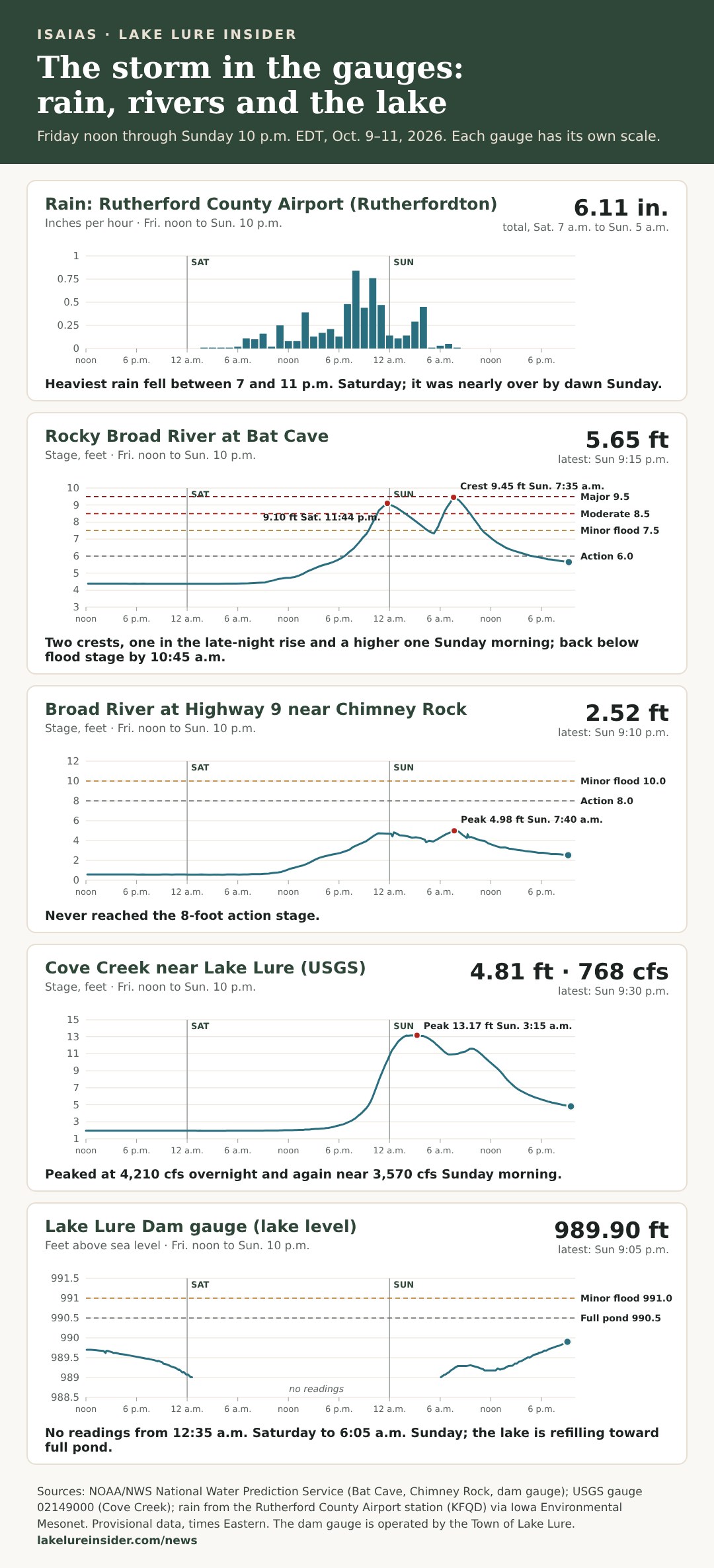
Rocky Broad at Bat Cave. The river sat near 4.4 feet Friday. It began climbing Saturday afternoon, passed the 6-foot action stage about 6:45 p.m. and the 7.5-foot minor flood stage at 9:35 p.m., and reached the 8.5-foot moderate stage at 10:44 p.m. It hit a first crest of 9.10 feet at 11:44 p.m., eased to about 7.3 feet around 5 a.m., then rose again to 9.45 feet at 7:35 a.m. It fell below moderate stage at 9:15 a.m., below minor stage at 10:45 a.m., and below action stage at 4:45 p.m. It read 5.65 feet at 9:15 p.m., still about 1.3 feet above where it started.
Broad River near Chimney Rock (Highway 9). This gauge went from about 0.6 foot Friday to a first peak near 4.8 feet shortly after midnight and a higher peak of 4.98 feet at 7:40 a.m. It never reached the 8-foot action stage and was 2.52 feet at 9:10 p.m.
Cove Creek near Lake Lure. The USGS gauge east of the dam peaked at 13.17 feet at 3:15 a.m. Sunday, with flow of about 4,210 cubic feet per second near 2:30 a.m. It eased, rose again to about 3,570 cubic feet per second at 9:45 a.m., then fell steadily. At 9:30 p.m. it read 4.81 feet and 768 cubic feet per second, still more than 13 times its 55.5 cubic feet per second Friday noon.
The lake. The NWS gauge at the dam fell from about 989.7 feet Friday noon to 989.0 feet just after midnight Saturday, and then reported nothing until 6:05 a.m. Sunday, when it resumed at 989.01 feet. It has risen since, to 989.90 feet at 9:05 p.m. The full-pond level is 990.5 feet, and the NWS lists minor flood stage at 991.0 feet. The Town's 8:10 a.m. Sunday update gave a planned lake range of 989.5 to 990.5 feet.
Why the rivers rose, fell, and rose again
If you watched the gauges overnight, the pattern looked strange: the Rocky Broad crested, started falling, and then climbed higher. The rain record explains most of it.
The rain came in pulses. The first big pulse, 7 to 11 p.m. Saturday, drove the first crest at Bat Cave at 11:44 p.m., just as the heaviest rain was ending. Then came the lull after midnight. With less rain feeding the river, it dropped nearly two feet, from 9.10 to roughly 7.3 feet. The second pulse, roughly 3 to 5 a.m., arrived on hillsides that were already soaked, so much of it ran straight off. About two and a half to four and a half hours later the river crested again, higher than the first time, at 9.45 feet.
Water takes time to arrive. A raindrop that lands high in the watershed does not reach a gauge instantly. It runs down slopes, into creeks, and then into the river, and the gauge sees the combined flow from many places at different travel times. That is why the river kept rising for hours after the heaviest rain at the airport had stopped. The NWS said in its Sunday-morning Flood Watch that runoff from earlier rain would keep water high even after the rain tapered off.
Smaller creeks react faster. Cove Creek drains a smaller area than the Rocky Broad, and its first peak came at about 3 a.m., before the Bat Cave river had its second crest. Its flow then eased and bumped back up Sunday morning as the later rain ran off. Its curve has the same two pulses, just earlier and sharper.
The two river gauges moved together on the second crest. Bat Cave crested at 7:35 a.m. and Chimney Rock at 7:40 a.m., five minutes apart, which fits a river responding to the same pulse of rain across the gorge.
Then the fall. Once the rain stopped around dawn, each gauge dropped fast at first and then more slowly. That slow tail is normal after a soaking: the hillsides keep releasing stored water into the creeks for days. It is why Bat Cave is still above its Friday level and Cove Creek is still far above its Friday flow Sunday night.
The lake is a different kind of gauge. A lake rises when more water flows in than flows out. The dam gauge cannot tell us how much is coming in, how much is being released, or what any gate is doing. What it shows is that the lake went from 989.01 feet at 6:05 a.m. to 989.90 feet by 9:05 p.m., a rise of about nine-tenths of a foot, and that it is inside the Town's stated planned range.
What the storm did, as far as we can confirm
- Rivers and roads. Rutherford County Emergency Management confirmed to us Sunday morning that the Broad River was over the temporary road at Dogwood Campground, between Bat Cave and Chimney Rock, and that it was closed. NWS storm reports said the NC Department of Transportation reported flooding on US 64/74 near Dogwood RV Park at 3:14 a.m., on SR 9 at Bat Cave with all lanes closed at 4:44 a.m., and on US 221 near Alexander Mills with all lanes closed at 4:40 a.m. WLOS reported closures of parts of Highway 9 and Highway 64 around Bat Cave. We have not confirmed which of these roads have reopened.
- Sirens. Rutherford County sounded flood sirens several times, including for the Fall Creek area north of Chimney Rock at 10:15 p.m. Saturday, per the county as reported by WLOS. Spectrum News reported more sirens in the Chimney Rock area Sunday morning.
- Landslides. The NWS confirmed landslides in McDowell County, including on NC 226-A near the county line and on Bear Wallow Road.
- Dam gate operations. The county said in alerts at 12:10 a.m. and 7:45 a.m. Sunday that Lake Lure officials had opened the dam's Tainter gates to 3 feet and then increased the opening to 6 feet. We have not independently confirmed gate operations with the Town, and we do not know the opening tonight.
- A resident's view. Tonja Gentry, who lives near the river, told WLOS the rise was far below what she saw during Helene but still worried her: "It's bothersome. My house is very exposed."
- Elsewhere. Spectrum News reported at least four storm-related deaths overall, including two people killed when trees fell on homes in Florida and Alabama, and a water rescue on the Catawba River in Burke County. As of Sunday night we had not seen a confirmed report of a death or serious injury in Lake Lure, Chimney Rock or Bat Cave, but we have not been able to confirm that with county officials.
What the National Weather Service says is next
The NWS forecast discussion issued at 8:17 p.m. Sunday says the remnants of Isaias are moving northeast and that drier weather is settling in. It listed no watches, warnings or advisories for its North Carolina counties. A few spotty showers are possible over the mountains early on, and the NWS says they should not cause problems in areas that flooded. A cold front tonight brings gusty northwest winds of 30 to 40 mph across the mountains, below Wind Advisory criteria, easing Monday afternoon. High pressure then builds, with dry weather and a warming trend into midweek. Light rain could return Thursday, and a stronger cold front could arrive by the weekend with a chance at the coldest temperatures of the season.
What to do now
- Stay off flooded roads and away from the river. The Rocky Broad and Broad River are falling but still carrying more water than normal, and the banks are wet and unstable. NWS guidance is Turn Around, Don't Drown.
- Watch for slides and debris. After more than five inches of rain on steep ground, the NWS warned of landslides and debris flows. Look for fresh mud, rocks and fallen trees on mountain roads.
- Expect wind tonight. Saturated ground plus gusts of 30 to 40 mph can bring down more trees, especially on the high ground.
- Check road status before you go. Use DriveNC and Rutherford County Emergency Management's Facebook page rather than assuming a road has reopened.
What we still do not know
- Why the dam gauge went silent. The gauge was silent from 12:35 a.m. Saturday to 6:05 a.m. Sunday. The Town of Lake Lure has not answered why, or what it used for lake levels in the meantime.
- Release rates. The county's alerts gave gate openings of 3 and 6 feet, not flows. We still do not know how much water went through the dam, who decided the gate settings overnight, or what the gates are set to now.
- Damage. As of Sunday night we had not seen a damage tally from the county or the Town.
Our questions to the Town, and no reply
At 12:32 a.m. Sunday, Lake Lure Insider emailed the Town of Lake Lure's communications office with six questions about the dam gauge: who operates and maintains it, when and why it stopped reporting, whether it is being repaired, what source the Town used for its posted lake levels, whether there is an official lake level and release rate and who makes the overnight release decisions, and where residents should look for official lake levels while the gauge is down. We asked for a response by 10 a.m. Sunday. As of about 10 p.m. Sunday, we had not received a reply. If the Town responds, we will add its answer here.
Sourcing Note
This story is based on National Weather Service Greenville-Spartanburg products: the Public Information Statement issued Friday evening, the Record Event Report issued at 2:26 a.m. Sunday, local storm reports from Sunday morning, and the Area Forecast Discussion issued at 8:17 p.m. Sunday; gauge data from the NOAA National Water Prediction Service and the U.S. Geological Survey (gauge 02149000), retrieved Sunday night; hourly rain at the Rutherford County Airport (KFQD) and CoCoRaHS volunteer rain reports, both retrieved through the Iowa Environmental Mesonet; and reporting from WLOS, Spectrum News and 828newsNOW. Rutherford County Emergency Management alerts and the Town of Lake Lure's 8:10 a.m. Sunday update were provided to us. All gauge and rain data are provisional and may be revised. We have not independently confirmed gate operations with the Town of Lake Lure. The explanation of the two crests is our reading of the rain and gauge records and is consistent with, but not confirmed by, a hydrologic analysis from the NWS.
Sources:
- Remnants of Isaias cause landslides, flash flooding in NC mountains, Spectrum News
- Isaias brings record rain, flooding to Asheville area, 828newsNOW
- Western NC counties respond to impacts from Isaias' remnants, WLOS
- WNC faces road closures and thousands without power Sunday, WLOS
- Bat Cave resident expresses concern as Broad River levels remain elevated, WLOS
- NWS Greenville-Spartanburg
Have a question, a tip, or news we should be covering?
Contact Lake Lure Insider →
Last updated: 2026-10-11