Hurricane Isaias and Lake Lure: What to Expect This Weekend
Storm Coverage — Lake Lure, NC — Updated October 9, 2026
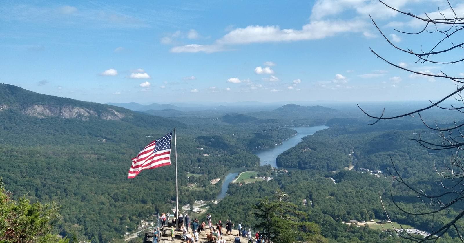
Photo: Ferd Prod (CC BY-SA 4.0)
LAKE LURE, N.C. — Hurricane Isaias is not tracking toward Lake Lure, but its rain is. The storm is a major Category 3 hurricane this morning and is expected to make landfall near Pensacola, Florida, tonight, then move north across the Deep South through Saturday. The National Weather Service says rainfall amounts for our area have increased, and the greatest flood risk is along the Blue Ridge Escarpment, which includes the area around Lake Lure. The NWS peak flooding threat runs from Saturday afternoon through early Sunday.
The storm
Isaias became the first hurricane of the 2026 Atlantic season on Wednesday night and then intensified rapidly. As of Friday morning it had maximum sustained winds near 120 mph, about 170 miles south-southeast of the mouth of the Mississippi River, moving north-northeast at 15 mph. A hurricane warning covers the coast from Ocean Springs, Mississippi, to the Bay/Gulf County line in Florida, with a storm surge warning from the mouth of the Mississippi to the Suwannee River. One outlet reports the storm is expected to weaken to a Category 2 by landfall.
After landfall Isaias is expected to weaken as it moves north, staying west of the Carolinas. The strongest winds will stay far to our west. NWS Greenville-Spartanburg does say a low-end tornado threat will accompany the storm Saturday and Saturday night, mainly along and south of the I-85 corridor, with low confidence. Lake Lure is north of that corridor.
The rain
Rain is the story here. NWS Greenville-Spartanburg's Friday morning briefing says rainfall amounts have increased across the area.
- Timing: Rain develops Saturday morning and continues into Sunday morning. Excessive rainfall is possible Saturday night and Sunday morning, mainly along the Blue Ridge Escarpment, northeast Georgia, and the western Upstate.
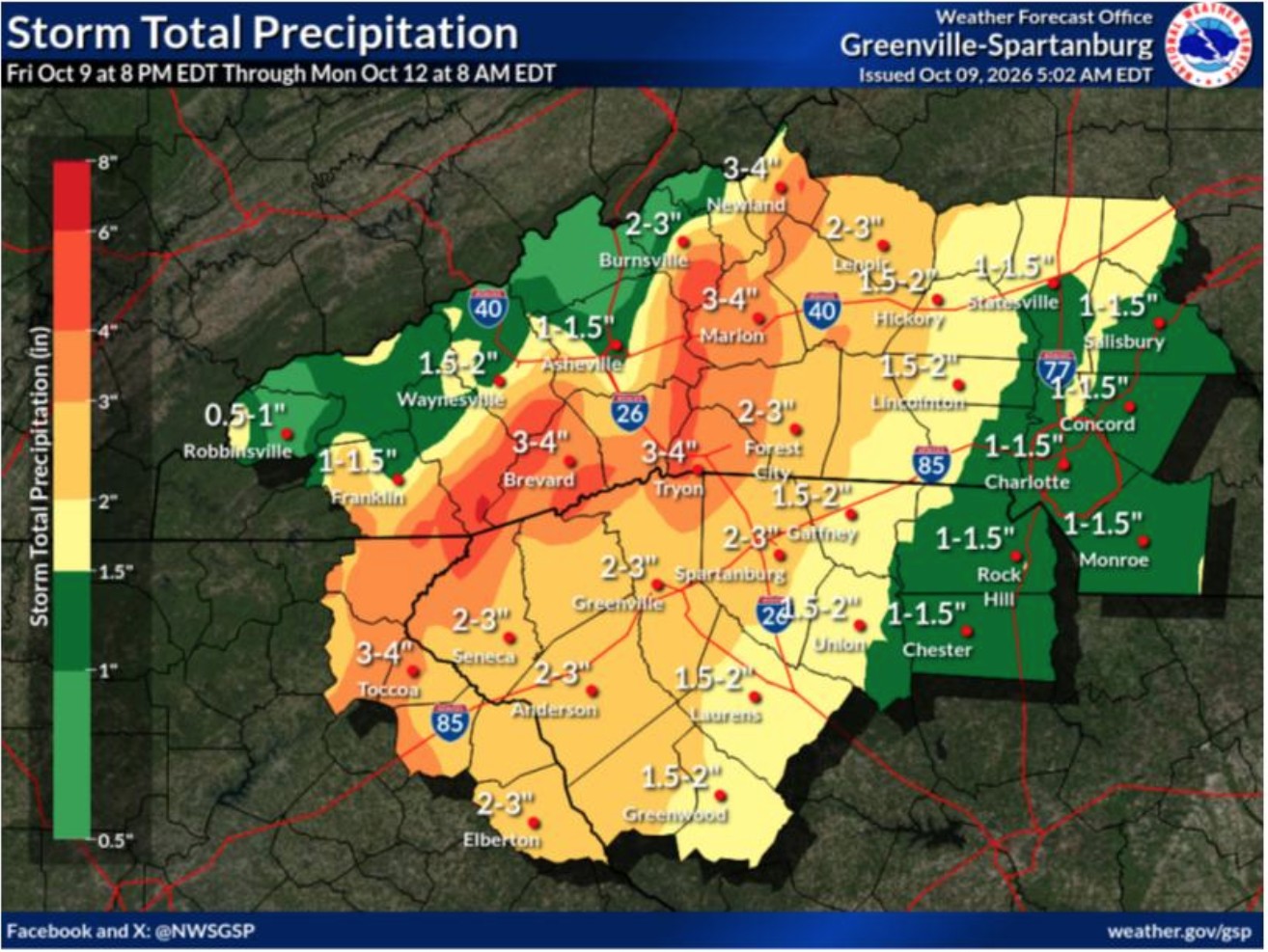
- Amounts: Totals are mostly expected in the 1 to 3 inch range, with locally higher amounts on the southeast-facing slopes of the Appalachians. The NWS storm-total map above labels Tryon, Brevard, and Marion at 3 to 4 inches, Forest City at 2 to 3, Asheville at 1 to 1.5, and Charlotte at 1 to 1.5. Lake Lure is not labeled. It sits between Tryon and Marion, in the heavier band along the escarpment, so our reading of the map is about 3 to 4 inches with locally higher amounts. That reading is ours, not an official Lake Lure total.
- Confidence and flooding: NWS rates confidence in the rainfall forecast as moderate. It says some nuisance to minor flooding is possible along streams and in low-lying areas, but widespread flash flooding or moderate flooding on the main rivers is unlikely.
- Flood Watch: A Flood Watch was not in effect at the time of the briefing but was being considered. If one is issued, NWS says it would come later Friday and be generally confined to the Blue Ridge Escarpment. Check weather.gov for the latest.
The NWS forecast for Lake Lure itself, issued Friday at 6:43 a.m., calls for:
- Friday night: 30% chance of showers after 3 a.m., under a tenth of an inch.
- Saturday: Showers, heavy at times, 90% chance. One to two inches of new rain possible. Northeast wind 10 to 15 mph, gusting to 25 mph. High near 65.
- Saturday night: Showers, with thunderstorms possible after 11 p.m., some producing heavy rain. 100% chance. One to two more inches possible.
- Sunday: Showers likely, with a possible thunderstorm before 1 p.m., then a chance of showers. 70% chance. High near 75.
- Monday: Sunny, high near 80.
National outlets are citing "up to 10 inches" as a possible isolated amount in the Southern Appalachians. That is a worst-case figure, not the NWS forecast for our area. Western North Carolina officials have also publicly dismissed a viral social media claim of 15 to 30 inches as not a forecast.
Unlike Helene, conditions are dry going in. Today is mostly cloudy and near 76 with no rain expected. For comparison, Helene put about 15 inches of rain into Lake Lure in September 2024, after days of earlier rain.
Wind and power
NWS expects gusty winds to pick up Saturday morning and linger into Sunday morning. Across most of the area it expects sustained winds of 15 to 25 mph with gusts of 25 to 35 mph. Above 3,000 feet, sustained winds of 25 to 35 mph and gusts of 45 to 55 mph are likely, which could cause isolated power outages. NWS says a Wind Advisory is being considered for the higher elevations of the North Carolina mountains, and would be issued later Friday if so. The Lake Lure point forecast shows gusts to about 25 mph.
What the Town is doing
The Town of Lake Lure says staff are proactively preparing for the rainfall forecast. In a Facebook post Friday morning, the Town said staff lowered the lake about 1 foot below full pond (990.5 feet MSL) to help accommodate anticipated precipitation. The post gave the current lake elevation as 989.69 feet MSL, up slightly from the 989.65 reported Thursday, and said the plan is to maintain the lake at about this level. Staff will continue monitoring forecasts and lake conditions, and the Town said any changes will be communicated through its official channels. The post came after the NWS briefing that raised rainfall amounts.
For context, before Helene the Town lowered the lake to 3 feet below full pond. In neighboring Polk County, officials are lowering Lake Adger by 2 feet to add storage ahead of this storm. We are not suggesting the Town's choice is wrong. The forecast and conditions differ from those storms, and we asked the Town to explain its reasoning, as described below.
The dam's release capability is different from what it was during Helene. After that storm the lake was drawn far down for months while the Army Corps of Engineers cleared sediment and debris, and crews replaced the seals on the dam's Tainter gates. The lake reopened to the public in May 2026. According to an engineering review summarized in Town Council minutes, the Tainter gate spillway can pass roughly 3,000 to 5,000 cubic feet per second, depending on gate position and lake level, and the low-level reservoir drain can pass another 1,000 to 1,500 cfs. Those are engineers' estimates, not guarantees. During Helene, the Town's own after-storm memo estimates peak outflow near 30,000 cfs with the gates fully open.
What we asked the Town, and the response
On Thursday, October 8, ahead of the storm, Lake Lure Insider emailed questions to the Town's communications director, with separate emails to Mayor Carol Pritchett and Commissioner Jim Proctor. The Town's own weather post directs questions to Communications@townoflakelure.com, which is where we sent ours. We asked:
- What rainfall total the Town's plan is built around, and what lake level or inflow would trigger further lowering
- Why the Town chose a smaller drawdown than before Helene, and how quickly the gates and low-level outlet can release water if the forecast worsens
- Who makes lake-level decisions overnight Saturday into Sunday, and whether any limit applies to how fast the lake can be lowered
- How downstream communities and Rutherford County Emergency Management would be notified if gates are opened
- What Everbridge alerts will be sent and what triggers them
- Which Helene repairs, if any, remain incomplete, and whether a post-Helene review will be made public
The Town's communications director acknowledged the request Thursday afternoon and forwarded it to the Town Manager and Town Clerk because it included a public records request. We then asked the Town to answer the non-records questions separately. As of 10:00 a.m. Friday, the Town had not answered them, and neither Mayor Pritchett nor Commissioner Proctor had replied to the emails we sent them. The Town's Friday morning Facebook post gives the lake level and its plan to hold it, which answers part of our first question, but it does not address the rainfall total the plan is built on, the reasoning for the smaller drawdown, how fast the gates can release water, who decides overnight, or how downstream communities would be notified.
We will update this article if the Town responds.
What residents and visitors should do
- Sign up for Everbridge. This is the Town's emergency notification system, and it can reach you by text, email, or phone call. If you haven't registered, do it before the weekend:
- Go to the Town's Everbridge sign-up page: member.everbridge.net/305943405396052/login. The Town's registration instructions are also at townoflakelure.com/node/3608.
- Create an account.
- Enter your contact information (phone, text, and email) and your location.
- Under Alert Subscriptions, select "Emergent/Pertinent Information."
- Questions: Communications@townoflakelure.com.
- Secure your property. Move boats, docks, kayaks, and loose items away from the shoreline. The Town has urged residents to secure property near the lake and protect pets.
- Prepare for power outages. Report outages to Duke Energy or Rutherford Electric Membership Corporation. Charge phones and keep flashlights and batteries handy. Emergency officials recommend supplies for at least 72 hours.
- Never drive through floodwater. When a flash flood warning is issued, move to higher ground immediately. Don't walk or drive through moving water, since the road under it may be washed out.
- Watch small streams. Polk County's emergency director warned that tributaries that haven't flooded before may flood this time.
- Watch for mudslides and downed trees. Steep slopes and saturated ground can shift quickly. Heavy rain on this terrain has caused tree falls and power loss before.
- Visitors: Saturday afternoon through early Sunday is the likely trouble window. Check the forecast before traveling, and consider adjusting plans.
Where to get updates
- The Town of Lake Lure's website and Facebook page for lake levels and emergency notices
- Everbridge alerts
- The National Weather Service Greenville-Spartanburg office for rainfall forecasts and any Flood Watch or Wind Advisory
- Questions for the Town: Communications@townoflakelure.com
Sourcing Note
This story is based on NWS Greenville-Spartanburg's Isaias briefing and storm-total precipitation map (Oct. 9, 2026); the National Weather Service forecast for Lake Lure (issued 6:43 a.m. EDT, Oct. 9, 2026); CBS News and WJHG reporting on Isaias's intensity and landfall (Oct. 9, 2026); WLOS reporting on Henderson and Polk County preparations (Oct. 8, 2026); the Town of Lake Lure's Facebook weather update (Oct. 9, 2026, 9 a.m.) and website notice (Oct. 8, 2026); the Town's Helene summary memo (Oct. 21, 2024); the Lake Lure Town Council meeting summary of Aug. 27, 2025; and Blue Ridge Public Radio's reporting on the lake's reopening.
Have a question, a tip, or news we should be covering?
Contact Lake Lure Insider →
Last updated: 2026-10-09