
Isaias Sunday Morning: A Second Round of Flash Flooding Pushes the Rocky Broad to Moderate Flood Stage, and the County Says Lake Lure's Dam Gate Opening Has Been Increased to 6 Feet
⚠ WEATHER ALERT · Storm Coverage — Lake Lure, NC — Sunday morning, October 11, 2026
LAKE LURE, N.C. — A second round of torrential rain early Sunday sent the Rocky Broad River at Bat Cave back up after it had begun to fall overnight. It crested at 9.45 feet at 7:35 a.m., 0.05 foot below its 9.5-foot major flood stage, and by 9:15 a.m. had fallen to 8.68 feet, still in the National Weather Service's moderate flood category. The NWS issued a Flash Flood Warning at 5:11 a.m. for the Bat Cave, Chimney Rock and Lake Lure area, saying evacuations may be needed, and renewed it at 9:35 a.m. for the Green and Upper Broad rivers, naming Lake Lure, Chimney Rock Village and Bat Cave, in effect until 11 a.m. Rutherford County emergency officials confirmed to Lake Lure Insider that the river is running over the temporary road at Dogwood Campground between Bat Cave and Chimney Rock and that the road is closed. Rutherford County Emergency Management said just after midnight that Lake Lure officials were opening the dam's Tainter gates to 3 feet, and at 7:45 a.m. that the opening was being increased to 6 feet, which sends more water into the Broad River below the dam. The Town of Lake Lure's 8:10 a.m. update put the lake at 989.24 feet and did not mention the gate operations.
The NWS expects the remnants of Isaias to push a cold front through the area by afternoon, ending the widespread rain, followed by a dry Monday and a warming trend. Until then, it says heavy bursts of rain can keep flooding going or cause new flooding.
This story was last updated at about 9:50 a.m. Sunday. Conditions are changing quickly, so check weather.gov/gsp and local officials' channels for anything newer. Our earlier coverage: Saturday night.
Where things stand at about 9:45 a.m.
- Road closed at Dogwood Campground. Rutherford County emergency officials confirmed to Lake Lure Insider that the Broad River is running over the temporary road at Dogwood Campground between Bat Cave and Chimney Rock and that the road is closed. The NWS had warned Saturday night that high flows on the Rocky Broad could flood US 64/74 (Main Street) near Dogwood RV Park. A reader also told us the river was in its channel in Bat Cave where US 64 and US 74 meet and that the new bridge there was fine; we have not confirmed those details independently.
- Flash Flood Warning until 11 a.m. Issued at 5:11 a.m. for southeastern Buncombe, eastern Henderson, Polk and northwestern Rutherford counties in North Carolina and parts of Greenville and Spartanburg counties in South Carolina, and renewed at 9:35 a.m. for Buncombe, Henderson, Polk and Rutherford counties. The 9:35 a.m. statement said river levels on the Green and Upper Broad were expected to remain elevated into the afternoon and listed Lake Lure, Chimney Rock Village and Bat Cave among places that will experience flash flooding.
- A second warning for Rutherford County was extended at 6:40 a.m. until 8:45 a.m. The NWS said 3 to 5 inches of rain had fallen, flash flooding was ongoing, and creeks and streams were running high, naming Cleghorn Creek in Rutherfordton, Floyds Creek near Forest City and Mountain Creek near Green Hill.
- Flood Watch until 2 p.m. for the Rutherford Mountains and surrounding zones. The NWS expects another 1 to 2 inches in places, with higher amounts locally, and says runoff from earlier rain will keep water high even after the rain tapers off.
- Flooding on SR 9 at Bat Cave. An NWS storm report at 12:44 a.m. said the NC Department of Transportation reported flooding on SR 9 near Bat Cave, between Bat Cave Drive and the Broad River, with all lanes closed. We have not checked whether that road has reopened.
The NWS wording in the 5:11 a.m. warning is direct: torrential rain was training over Bat Cave, Chimney Rock and Lake Lure; rises on the Broad River near Lake Lure could quickly worsen the ongoing minor flooding; significant flooding, potentially affecting some structures, could develop within one to two hours; and residents should "seek higher ground now."
What the river gauges show
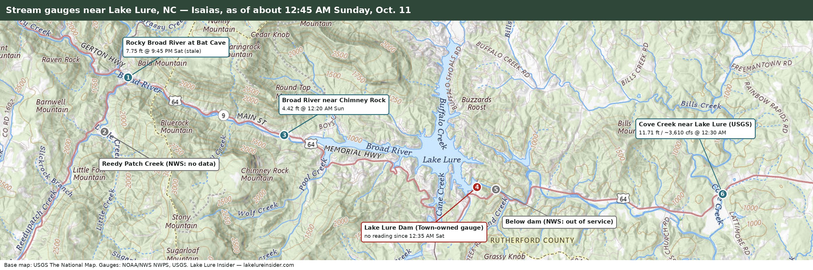
These are provisional, automatically collected readings from the NWS and the U.S. Geological Survey as of about 9:45 a.m. Each gauge has its own scale. Times are Eastern.
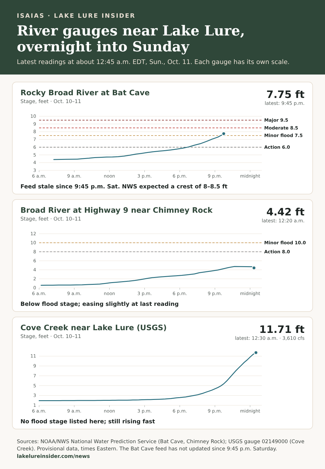
Rocky Broad at Bat Cave. The NWS lists minor flood stage at 7.5 feet, moderate at 8.5 feet and major at 9.5 feet. The river reached about 9.1 feet near 11:45 p.m. Saturday, fell to about 7.3 feet by 5:15 a.m., then climbed to a crest of 9.45 feet at 7:35 a.m., 0.05 foot short of major stage. It has been falling since: 9.00 feet at 8:45 a.m. and 8.68 feet at 9:15 a.m., still in the moderate category. The NWS gauge page showed no forecast crest when we checked.
Broad River near Chimney Rock. This gauge read 4.98 feet at 7:40 a.m. and 4.32 feet at 9:25 a.m., easing and well below its 10-foot minor flood stage. It sits upstream of the lake and the dam.
Cove Creek near Lake Lure. The U.S. Geological Survey gauge east of the dam peaked near 13.2 feet around 3 a.m., with flow near 4,210 cubic feet per second around 2:30 a.m., then fell to about 10.9 feet before turning back up. At 9:30 a.m. it read 11.57 feet and about 3,560 cubic feet per second. The NWS lists no flood category for this stretch.
The lake and the dam
Gate opening increased to 6 feet. In an alert at 7:45 a.m. Sunday, as provided to us, Rutherford County Emergency Management advised that Lake Lure officials were increasing the opening of the dam's Tainter gates from 3 feet to 6 feet, releasing additional water into the Broad River downstream of the dam. The county warned residents and businesses along the river below the dam to expect rising water, increased river flows and possible flooding in low-lying areas, and said water levels may rise quickly with little warning. It told people in flood-prone areas to move away from the river and seek higher ground, to stay away from riverbanks and fast-moving water, and not to drive through flooded roads. The alert gave no release rate or schedule. One note on terms: we are told the dam's gates open by being lowered, so a gate "lowered 1 foot" is a 1-foot opening, and a larger number means a wider opening and more water released.
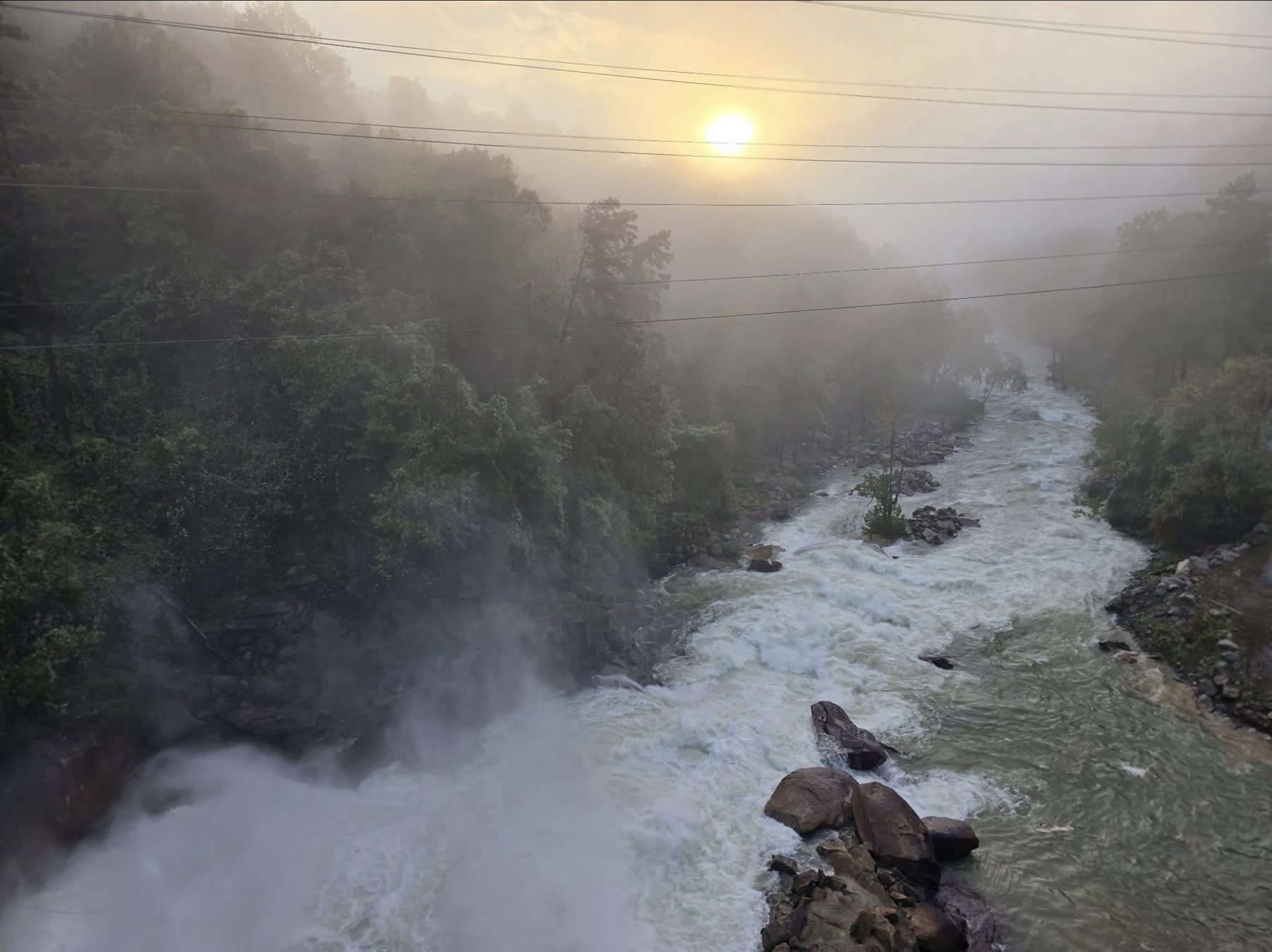
The earlier step: at 12:10 a.m. Sunday, Rutherford County Emergency Management advised that Lake Lure officials were opening the dam's Tainter gates to 3 feet, increasing the flow into the Broad River below the dam. The county told residents and businesses along the river below the dam to expect rising water and possible flooding in low-lying areas, to move away from the river, and not to drive through flooded roads. That alert also gave no release rate or schedule.
The NWS gauge at the dam reported nothing from about 12:35 a.m. Saturday until about 6 a.m. Sunday. It resumed at 989.01 feet, read 989.24 feet at 7:40 a.m. and 989.31 feet at 9:35 a.m., rising only slowly. That is below the 990.5-foot full pond and below the gauge's action stage of 990.6 feet. The Town's 8:10 a.m. Sunday update reports the same figure as the 7:40 a.m. gauge reading, 989.24 feet, so its numbers appear to come from this gauge. That is above the 988 feet the Town reported at 9:30 p.m. Saturday, a rise of about 1.2 feet. The Town's planned elevation is now 989.5 to 990.5 feet, up from the 987.5 to 988.5 feet range it listed Saturday night; the update does not say why it changed. It says staff "continue to monitor lake levels," that the Town made preparations to lower the lake further if needed, and that any changes will be communicated through Rutherford County Emergency Management and the Town's official channels, which may explain why the gate openings have come from the county. The update does not mention gate settings or release rates. It also says downstream residents have been contacted throughout the storm and that about 260 properties in the area were without power, a figure the Town attributed to Duke Energy. The NWS says it does not own, operate or maintain the dam gauge, credits its observations to the Town of Lake Lure and directs questions about data availability to the Town. The NWS lists its gauge below the dam as out of service, so there is no live reading of the river downstream.
What the National Weather Service says is next
In its 6:52 a.m. forecast discussion, the NWS Greenville-Spartanburg office said Post-Tropical Cyclone Isaias was centered over middle Tennessee and moving toward the Central Appalachians. A cold front trailing south from it was expected to sweep across the area and move east by afternoon, ending the widespread showers. Ahead of the front, additional heavy rain and an isolated thunderstorm were possible, with a risk that a storm could become severe and briefly produce a tornado, though the better chances were east of the area. The Flood Watch stays in place until the heavier showers move east.
Behind the front, gusty northwest winds of 25 to 35 mph are expected across the mountains tonight through Monday. The NWS point forecast for Lake Lure calls for patchy fog and a 20 percent chance of showers before 10 a.m. Sunday, then partly sunny with a high near 74. Monday is sunny with a high near 80, and Tuesday and Wednesday are forecast sunny with highs near 85 and 88. A backdoor cold front could bring light rain Thursday.
Dry weather does not mean the water drops right away. The NWS says runoff from the earlier rain will keep water levels high in parts of the area after the rain ends, and landslide risk stays elevated on saturated slopes.
What to do right now
- If you are near a stream, at the base of a mountain or in a cove, the NWS says to seek higher ground now. Evacuations may be needed.
- If you live or work along the Broad River below the dam, the county says to take precautions now: expect rising water and increased flows, move away from the river, and stay away from riverbanks and fast-moving water. It warns levels may rise quickly with little warning.
- Do not drive through floodwater and obey barricades. SR 9 near Bat Cave was reported closed by flooding overnight.
- If you suspect a landslide, the NWS says to stay indoors and not go outside to investigate, and to move upstairs or onto sturdy counters inside your home.
- Follow evacuation orders from local Emergency Management officials.
- Report flooding or landslides only when it is safe, to NWS Greenville-Spartanburg through its Facebook page or on X with #NWSGSP, giving the location and depth.
- Sign up for Everbridge if you haven't: member.everbridge.net/305943405396052/login.
- Report outages to Duke Energy or Rutherford Electric Membership Corporation.
What we still do not know
- How much water is being released and for how long. The county alerts gave gate settings (a 3-foot opening, then 6 feet), not a flow rate or schedule, and the Town's 8:10 a.m. update did not mention gate operations.
- Who is making the release decisions and what they are watching.
- Why the Town raised its planned lake elevation to 989.5 to 990.5 feet from 987.5 to 988.5 feet, and whether that is compatible with the gate openings the county described.
- Why the dam gauge went silent for about 29 hours and who is responsible for it. We asked the Town overnight and have not had a reply; see below.
- Where the Rocky Broad will crest at Bat Cave. The gauge had no forecast crest when we checked.
Where to get updates
- National Weather Service Greenville-Spartanburg for warnings, watches and forecasts
- NWS river gauges for the Rocky Broad, Broad River and Cove Creek
- The Town of Lake Lure's website and Facebook page for lake levels and emergency notices
- Rutherford County Emergency Management for evacuation and road information
- Questions for the Town: Communications@townoflakelure.com
Our questions to the Town about the dam gauge, and no reply yet
At 12:32 a.m. Sunday, Lake Lure Insider emailed the Town of Lake Lure's communications office, the address the NWS lists for questions about the dam gauge, and asked for a response by 10 a.m. Sunday. We asked:
- Who operates and maintains the dam gauge, and is it a Town-owned instrument?
- When did it stop reporting, and why?
- Is it being repaired, and when is it expected to resume?
- What source is the Town using for the lake levels it has been posting, and how often is it read?
- Is there a current official lake level and release rate, and who is making the overnight release decisions?
- Where should residents look for an official lake level while the gauge is down?
As of about 8:35 a.m. Sunday, we had not received a reply. The gauge has since started reporting again, which answers part of question 3, and the Town's 8:10 a.m. update gives a lake level that matches it, which bears on question 4. Questions 1, 2, 5 and 6 remain unanswered, and so does the question of who maintains the gauge. If the Town responds, we will add its answer here.
Sourcing Note
This story is based on National Weather Service Greenville-Spartanburg products retrieved Sunday morning: the Flash Flood Warning issued at 5:11 a.m. EDT, the Rutherford County Flash Flood Warning extended at 6:40 a.m., the Flood Watch issued at 6:13 a.m., the Area Forecast Discussion issued at 6:52 a.m., the Lake Lure point forecast, and a local storm report at 12:44 a.m.; gauge data from the NOAA National Water Prediction Service and the U.S. Geological Survey (gauge 02149000); Rutherford County Emergency Management alerts dated 12:10 a.m. and 7:45 a.m. Sunday and the Town of Lake Lure's 8:10 a.m. Sunday storm and lake-level update, all as provided to us. We have not independently confirmed the gate operations with the Town of Lake Lure. Gauge readings are provisional and can change. Lake Lure Insider is an independent local publication.
Have a question, a tip, or news we should be covering?
Contact Lake Lure Insider →
Last updated: 2026-10-11