
Isaias Saturday Night: Flash Flood Warnings Cover Lake Lure and Rutherford County, the Rocky Broad Is Over Flood Stage, and the Town Has Lowered the Lake to 988 Feet
⚠ WEATHER ALERT · Storm Coverage — Lake Lure, NC — Saturday night, October 10, 2026
Update, 12:10 a.m. Sunday: dam gates being opened. Rutherford County Emergency Management advised in an alert at 12:10 a.m. that Lake Lure officials are opening the dam's Tainter gates to 3 feet, which will increase the flow into the Broad River below the dam. The county said residents and businesses along the Broad River below the dam should expect rising water and possible flooding in low-lying areas, should move away from the river and avoid flood-prone areas, and should not drive through flooded roads. The Town has not yet said how much water this will release or how long the gates will stay open, and we have not independently confirmed the gate opening with the Town.
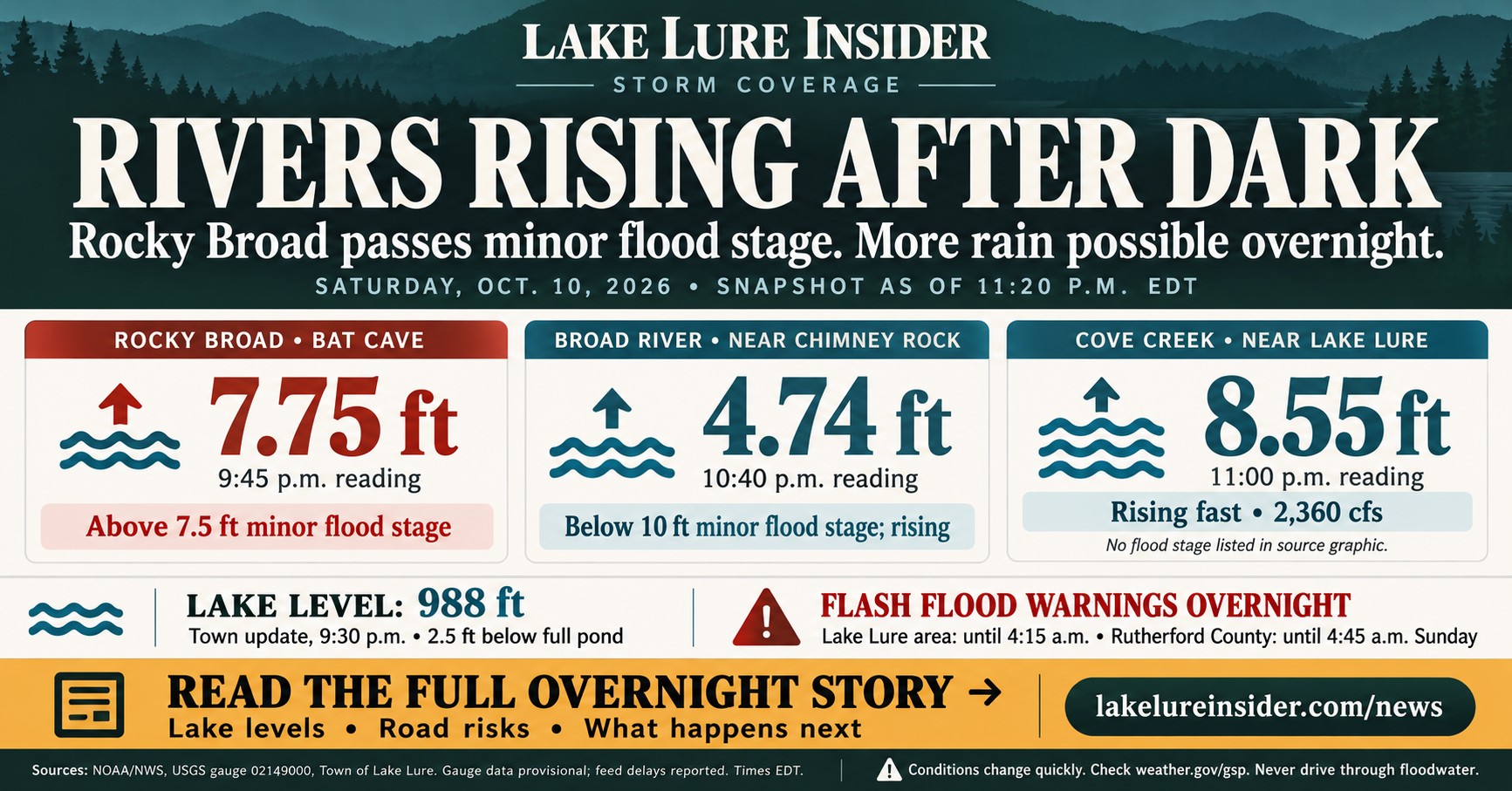
LAKE LURE, N.C. — Rounds of torrential rain Saturday night pushed the Rocky Broad River at Bat Cave past minor flood stage and brought two Flash Flood Warnings covering Lake Lure, Chimney Rock and Rutherford County. The National Weather Service says more heavy rain is possible until about dawn Sunday, with flash flooding "imminent or occurring" in parts of the county. The Town of Lake Lure had lowered the lake to 988 feet by its 9:30 p.m. update, about 2.5 feet below full pond.
This story was last updated at about 1:05 a.m. Sunday. Conditions are changing quickly, so check weather.gov/gsp and the Town's official channels for anything newer.
How Saturday went
Saturday was a long, steady rain that turned violent after dark. The National Weather Service's Greenville-Spartanburg office said in its 8:05 p.m. forecast discussion that rain had stayed showery most of the day, generally no more than an inch in three hours, but that the duration had already pushed some areas along the southeast-facing Blue Ridge Escarpment to about 3 inches. Creeks and streams were already responding.
That changed in the evening:
- 8:48 p.m., Flood Advisory for Rutherford County (until 8:45 a.m. Sunday). The NWS said widespread storm totals of 2.5 to 3.5 inches had fallen over the previous 12 hours on saturated soil, and that a thunderstorm producing torrential rain was moving south to north across the county. It named rapid rises on Cleghorn Creek in Rutherfordton, Floyds Creek near Forest City and Mountain Creek near Green Hill.
- 10:08 p.m., Flash Flood Warning for the Lake Lure area (until 4:15 a.m. Sunday). The warning covers southeastern Buncombe, northeastern Henderson and northwestern Rutherford counties. The NWS said rounds of torrential rain had hit the upper Broad and Rocky Broad watershed, "including over Lake Lure," with another 1 to 2 inches in the previous couple of hours on top of 3 to 4 inches over the prior 12. It listed Lake Lure, Chimney Rock Village, Chimney Rock State Park, Bat Cave, Gerton and Shingle Hollow among the places that may flood.
- 10:39 p.m., Flash Flood Warning for Rutherford County (until 4:45 a.m. Sunday). The NWS said 3 to 5 inches had fallen, with another 2 to 3 inches possible, and that flash flooding was ongoing or expected shortly. Locations named include Forest City, Rutherfordton, Spindale, Ellenboro, Bostic, South Mountains State Park, Alexander Mills, Sunshine, Union Mills and Caroleen.
The NWS also said high flows on the Rocky Broad into Chimney Rock would flood US 64/74 (Main Street) near Dogwood RV Park, and that "an isolated landslide or two cannot be ruled out."
What the river gauges show
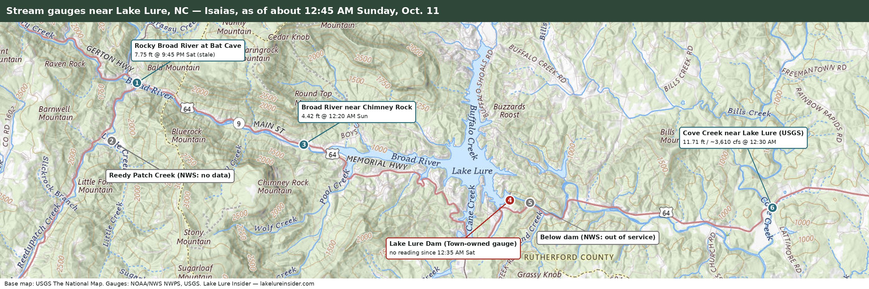
The National Weather Service posts readings from river gauges in the Lake Lure area. These are provisional, automatically collected numbers, and the most recent ones available to us at about 12:45 a.m. Sunday are below. The Bat Cave feed has not updated since 9:45 p.m. Saturday, so that reading is older than the others. Times are Eastern.
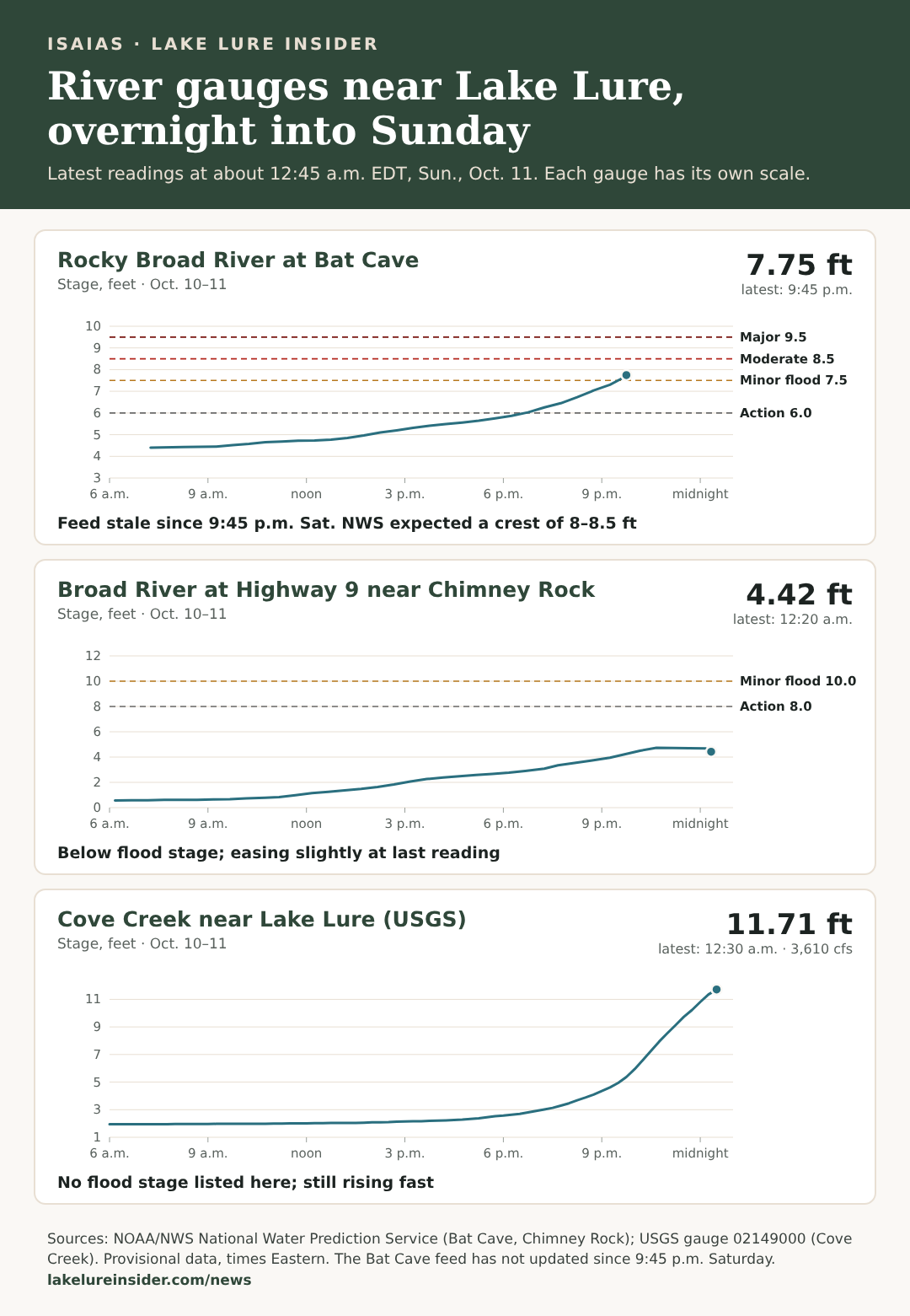
Rocky Broad at Bat Cave. The NWS lists minor flood stage at 7.5 feet, moderate at 8.5 feet and major at 9.5 feet. By 9:35 p.m. the river had passed 7.5 feet, and no newer reading had posted as of 12:45 a.m. Sunday, so we do not know whether it has crested. The 10:08 p.m. warning said it was expected to keep rising to 8 to 8.5 feet before slowing or cresting, which would put it at the top of the minor range, up to the 8.5-foot moderate threshold.
Broad River near Chimney Rock. This gauge read 4.74 feet at 10:40 p.m. and 4.42 feet at 12:20 a.m., so it has eased slightly and remains well below its 10-foot minor flood stage. We do not know why it dipped; it could reflect changes in releases from the dam or ordinary fluctuation.
Cove Creek near Lake Lure. This U.S. Geological Survey gauge, east of the Lake Lure dam, shows how fast the evening burst hit. Between 9:15 and 11 p.m. it climbed from 4.61 to 8.55 feet, and by 12:30 a.m. it read 11.71 feet with flow of about 3,610 cubic feet per second, up from about 2,360 at 11 p.m. and about 1,550 at 10:15 p.m. The NWS lists no flood category for this stretch, and it was still rising at the last reading.
One limit on this data: the gauge at the Lake Lure dam has not reported since about 12:35 a.m. Saturday, when it read 989.01 feet. The NWS displays that gauge but says it does not own, operate or maintain it; the NWS credits the observations to the Town of Lake Lure and directs questions about data availability to the Town. The NWS also lists its gauge below the dam as out of service. The lake levels in this story are therefore the Town's own posts. Open questions for the Town: who maintains the dam gauge, why it stopped reporting, when it will be fixed, and where residents can find an official lake level in the meantime.
The lake
The Town of Lake Lure's 9:30 p.m. update put the lake at 988 feet above mean sea level, down from 989.62 feet in its late-morning post. Full pond is 990.5 feet. The Town now lists its planned elevation as a range of 987.5 to 988.5 feet; the late-morning post said 988.5. The Town said it made preparations to lower the lake further based on the incoming rain, and that additional staff are on standby.
The Town's posts have given lake levels, but not how fast water is being released or who decides overnight. At 12:10 a.m. Sunday, Rutherford County Emergency Management said the Tainter gates were being opened to 3 feet; the county's alert did not give a release rate, and the Town's 9:30 p.m. post, the latest we have seen from the Town, did not mention gate operations. Lake Lure Insider has confirmed that the Town's flood sirens sounded Saturday night; we do not have the exact time, and the Town has not said what triggered them. Residents along the Rocky Broad River, around Lake Lure and downstream along the Broad River are asked to stay alert for sirens and voice messages and to follow instructions from local officials.
What happens overnight
- Flash Flood Warnings run until 4:15 a.m. for the Lake Lure area and 4:45 a.m. for Rutherford County. The Flood Advisory runs until 8:45 a.m.
- The Flood Watch continues through Sunday afternoon. At 10:47 p.m. the NWS said high rainfall rates will continue in short bursts through the overnight hours. By Sunday morning it expects totals of generally 5 to 8 inches along the southeast-facing Blue Ridge Escarpment and 2 to 5 inches elsewhere in the watch area.
- Landslides. The NWS says more than 5 inches of rain in similar storms has been associated with a higher landslide risk, especially fast-moving debris flows. Its discussion says bands of storms could produce 1 to 2 inches in as little as an hour and push some totals past 5 inches in 24 hours.
- Rivers. The NWS expects a few main rivers to reach flood stage, especially the French Broad and Pigeon, and says it cannot rule out flooding on the Broad.
- Storms and wind. The NWS says isolated severe storms are possible, mainly along and south and east of I-85, with a damaging-wind and brief-tornado risk. Gusts at most observation sites had dropped below 30 mph by the evening discussion, and the NWS said it would likely let the Wind Advisory and the high-elevation High Wind Warning go during the evening, while being less sure about the northern mountains and eastern Escarpment. Check weather.gov for the current status.
- When it ends. The NWS says the risks should diminish by Sunday morning, though a line of storms may not clear the eastern part of its area until about 8 to 11 a.m.
Sunday and beyond
Clouds should lift from west to east from late Sunday morning, though cloud cover is likely most of the day, and temperatures should return to near normal. Even after the rain ends, creeks and rivers may stay high and saturated slopes remain unstable. The NWS says gusty northwest winds of 25 to 35 mph may return to the mountains Sunday night into Monday as drier air arrives, with dry weather and a warming trend through the middle of next week.
What to do right now
- If you are near a stream or at the base of a mountain, the NWS says to be especially cautious at night, when flooding is harder to recognize. If heavy rain develops, seek higher ground immediately.
- If you suspect a landslide, the NWS says to stay indoors and not go outside to investigate, and to move upstairs or onto sturdy counters inside your home to avoid being swept away.
- Do not drive through floodwater and obey all barricades. US 64/74 in Chimney Rock near Dogwood RV Park is expected to flood.
- Follow evacuation orders from local Emergency Management officials.
- Report flooding or landslides only when it is safe, to NWS Greenville-Spartanburg through its Facebook page or on X with #NWSGSP, giving the location and depth.
- Sign up for Everbridge if you haven't: member.everbridge.net/305943405396052/login.
- Report outages to Duke Energy or Rutherford Electric Membership Corporation.
Where to get updates
- National Weather Service Greenville-Spartanburg for warnings, watches and forecasts
- NWS river gauges for the Rocky Broad, Broad River and Cove Creek
- The Town of Lake Lure's website and Facebook page for lake levels and emergency notices
- Questions for the Town: Communications@townoflakelure.com
Sourcing Note
This story is based on the National Weather Service Greenville-Spartanburg Flood Advisory (8:48 p.m. EDT, Oct. 10, 2026), Flash Flood Warnings (10:08 p.m. and 10:39 p.m. EDT), Flood Watch statement (10:47 p.m. EDT) and Area Forecast Discussion (8:05 p.m. EDT); the Town of Lake Lure's Facebook weather updates (late morning and 9:30 p.m., Oct. 10, 2026); and river gauge data from the National Weather Service's National Water Prediction Service (Bat Cave and Chimney Rock) and the U.S. Geological Survey (Cove Creek, gauge 02149000), retrieved at about 11:20 p.m. EDT. Gauge readings are provisional and may be revised. Times in the gauge graphic are Eastern, converted from the service's UTC timestamps.
Have a question, a tip, or news we should be covering?
Contact Lake Lure Insider →
Last updated: 2026-10-10