Isaias Update: Flood Watch and Wind Advisory Issued for Lake Lure Area, and the Town Is Now Lowering the Lake
Storm Coverage — Lake Lure, NC — Friday night, October 9, 2026
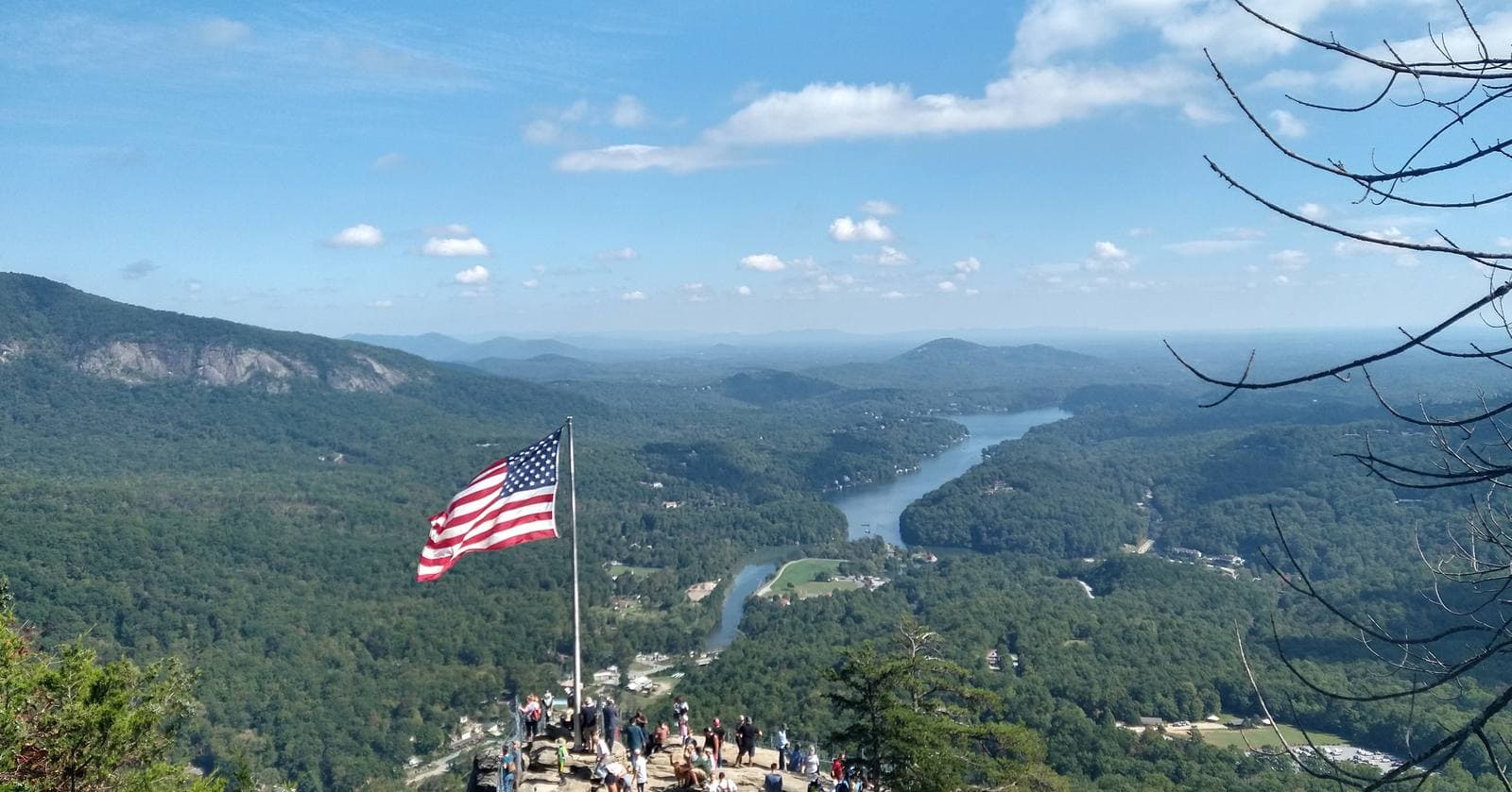
Photo: Ferd Prod (CC BY-SA 4.0)
LAKE LURE, N.C. — The National Weather Service has issued a Flood Watch for Rutherford County and much of western North Carolina from Saturday morning through Sunday afternoon, and a Wind Advisory for the Rutherford County mountains begins at midnight. The Town of Lake Lure changed its lake plan Friday evening: it is now lowering the lake to 988.5 feet, about 2 feet below full pond, and says it may lower it another foot if needed.
The advisories arrive as Hurricane Isaias nears landfall on the western Florida Panhandle. The storm's center will pass far to our west, but its rain will not.
The storm
The National Hurricane Center's 8 p.m. EDT update (7 p.m. CDT) put Isaias about 45 miles southeast of Pensacola, Florida, with maximum sustained winds of 110 mph, down from 120 mph earlier in the day, moving north at 18 mph. The center expects landfall on the western Florida Panhandle within an hour or two of that advisory. A weather station at Gulf Breeze, Florida, recently reported a sustained wind of 83 mph and a gust of 97 mph.
After landfall the center is expected to move across Alabama and into the Tennessee Valley on Saturday and Sunday, and Isaias is forecast to become a post-tropical system on Saturday. The Hurricane Center warns of a life-threatening storm surge from the mouth of the Mississippi River to the Suwannee River, with surge of 6 to 9 feet above ground forecast from the Alabama–Florida border to Grayton Beach.
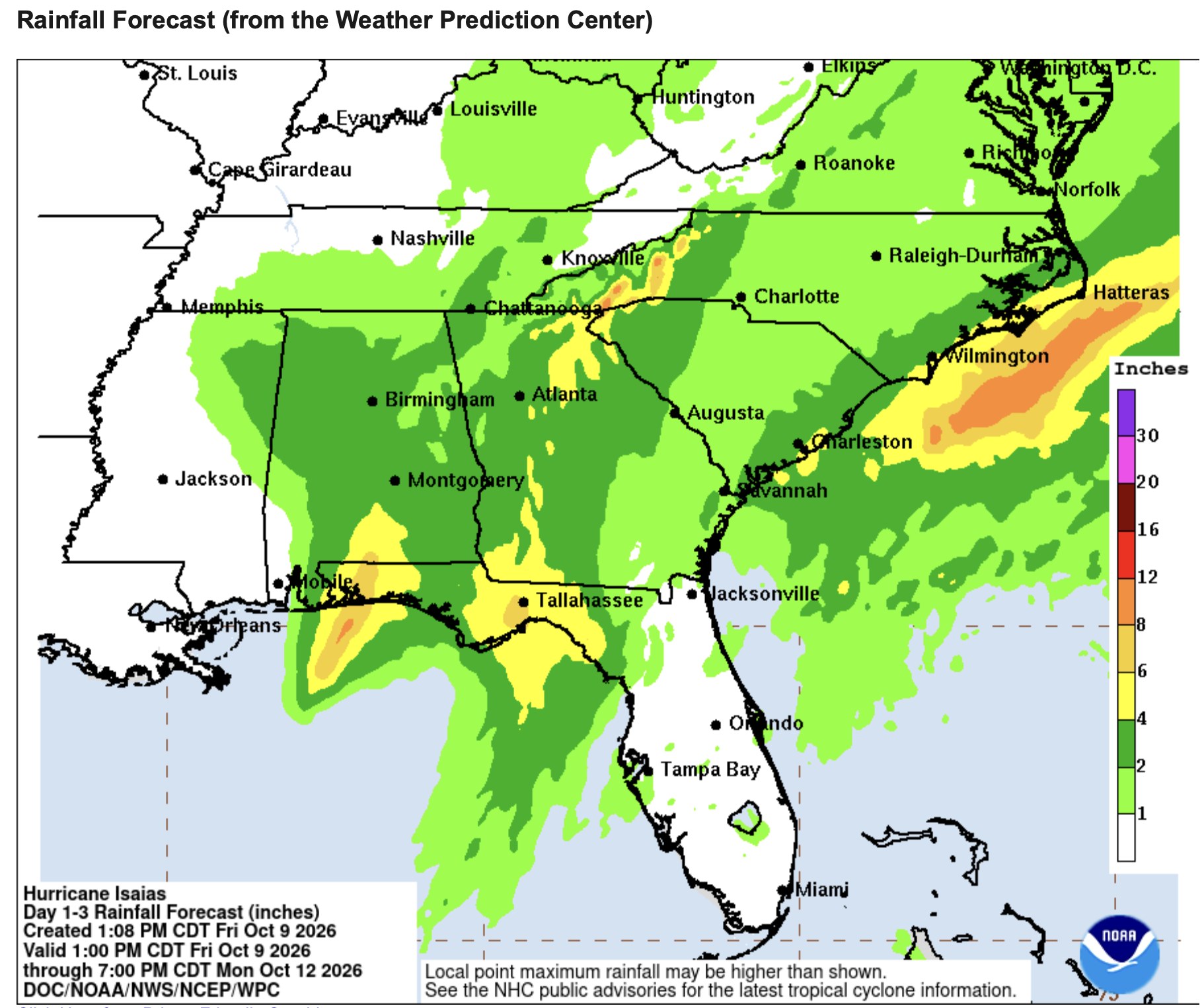
For the Southern Appalachians, the Hurricane Center expects rainfall of 2 to 5 inches across much of the Southeast, with localized amounts up to 10 inches possible, especially across the Southern Appalachians and coastal Carolinas. It says considerable flash flooding and landslides are possible across the Southern Appalachians, and that damaging wind gusts are likely over a large part of the Southeast, including the southern Appalachians, especially in areas of higher terrain. The tornado threat continues Saturday across parts of the Carolinas. The next full advisory is due at 11 p.m. EDT.
Flood Watch for Rutherford County
NWS Greenville-Spartanburg issued the Flood Watch at 2 p.m. Friday. It runs from Saturday morning through Sunday afternoon and covers Rutherford, Polk, Henderson, Buncombe, McDowell, Transylvania, Burke, Caldwell and several other western North Carolina counties, plus parts of northeast Georgia and Upstate South Carolina. The watch lists Chimney Rock State Park and Cove Creek among the places it covers.
NWS says flash flooding caused by excessive rainfall is possible. Its details:
- Timing: Periods of rain may begin before dawn Saturday, with light rates at first. Rates increase during the day, and heavy rain is most likely Saturday afternoon through early Sunday morning.
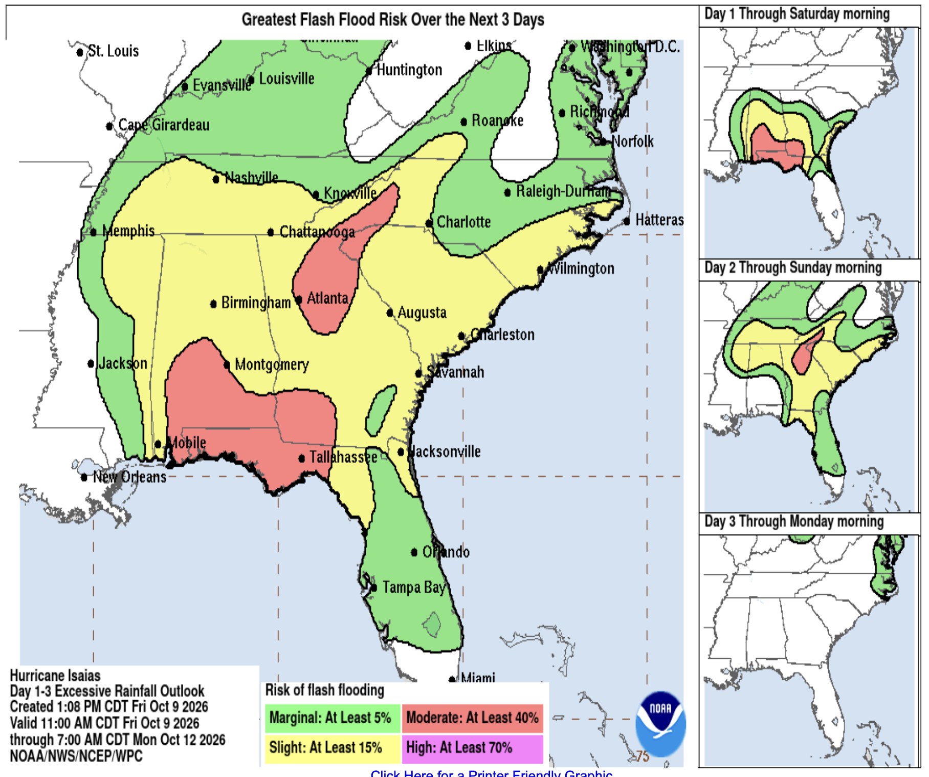
- Where: The heaviest rain is expected along the south- and east-facing Blue Ridge Escarpment, near the North Carolina–South Carolina line west of I-26, and in the sharp terrain from near Saluda to Grandfather Mountain.
- Impacts: Excessive runoff may flood rivers, creeks, streams, and low-lying and flood-prone locations. Creeks and streams may rise out of their banks, and low-water crossings may flood.
- Landslides: NWS says rainfall of more than 5 inches in similar storms has been associated with an increased risk of landslides and rockslides. If you live on a mountainside or in a cove at the base of a mountain, especially near a stream, NWS says to be ready to leave before the storm or as quickly as possible if rising water, moving earth or rocks threaten. It advises considering postponing travel on mountain roads during heavy rain.
A Flood Watch means flooding is possible, not that it is happening. NWS says to monitor the latest forecasts and be ready to act quickly if Flash Flood Warnings are issued.
Wind Advisory
NWS issued a Wind Advisory for northeast Georgia, the western Upstate, Avery and Henderson Counties, and the mountain portions of Polk, Rutherford, McDowell, Burke and Caldwell Counties. It lists Chimney Rock State Park among the places affected. It runs from midnight tonight until 8 a.m. Sunday, with east winds of 10 to 20 mph and gusts up to 46 mph.
NWS says gusty winds will blow around unsecured objects, including portable tents. Tree limbs could come down and a few power outages may result. Winds this strong can make driving difficult, especially for high-profile vehicles.
The Town changes its plan
The Town of Lake Lure's 9 a.m. Friday Facebook post said the lake was at 989.69 feet and that the plan was to hold it near that level. At 5 p.m. the Town posted a different plan.
- The Town said staff are in the process of lowering the lake to 988.5 feet MSL as a precaution. The lake was at 989.67 feet at the time of the post. Full pond is 990.5 feet.
- Based on an update from the National Weather Service Friday afternoon, the Town said it is preparing for the possibility of lowering the lake by another foot, if needed. Another foot would take the lake to 987.5 feet. The Town's own pre-Helene notice put the lake at 987.5 feet, 3 feet below full pond.
- The Town said the heaviest rain is expected in Lake Lure and the Rutherford County mountains, and that creeks and rivers may rise quickly.
- The Town told residents along the Rocky Broad River, around Lake Lure, and downstream along the Broad River to remain alert for flood sirens and voice messages, and to follow instructions if sirens sound.
The Town did not say in the post how long it will take to reach 988.5 feet, how quickly the dam's gates can release water, or what rainfall total its plan is built around.
What the Town hasn't answered
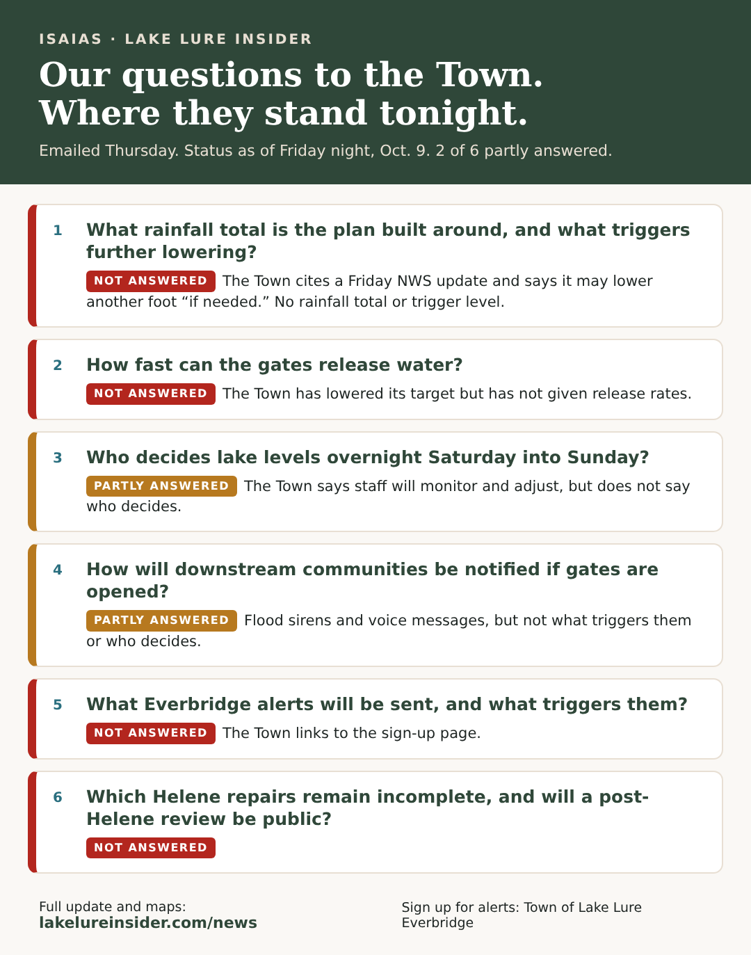
Lake Lure Insider emailed questions Thursday to the Town's communications director, Mayor Carol Pritchett and Commissioner Jim Proctor. The communications director first forwarded the request to the Town Manager and Town Clerk because it included a public records request. At 5:30 p.m. Friday she wrote to close out our inquiry: "To close the loop on your inquiry, all pertinent information regarding storm preparations can be found on the website under Town News." The mayor and Commissioner Proctor had not replied as of 10 p.m. Friday.
The Town's posts have since answered parts of what we asked, including the current lake level, the new target, and a flood siren and voice message alert for the river corridor. Here is where each of our questions stands:
We will update this story if the Town provides more.
What residents and visitors should do
- Sign up for Everbridge if you haven't: member.everbridge.net/305943405396052/login. Under Alert Subscriptions, select "Emergent/Pertinent Information."
- Know the flood sirens. If you live along the Rocky Broad River, around Lake Lure or downstream along the Broad River, be ready for sirens and voice messages and follow the instructions.
- Know your landslide risk. If you live on a mountainside or in a cove near a stream, plan now where you would go, and consider leaving before the heaviest rain Saturday afternoon.
- Secure property. Move boats, docks, tents, furniture and loose items before the midnight wind advisory begins. Protect pets.
- Prepare for power outages. Report outages to Duke Energy or Rutherford Electric Membership Corporation. Charge phones and have flashlights, batteries, water and food ready.
- Don't drive through floodwater, and consider postponing travel on mountain roads Saturday afternoon through Sunday morning.
- Check on neighbors, especially anyone who may not see online alerts.
Where to get updates
- National Weather Service Greenville-Spartanburg for Flood Watch, Flash Flood Warning and Wind Advisory updates
- National Hurricane Center for storm advisories
- The Town of Lake Lure's website and Facebook page for lake levels and emergency notices
- Questions for the Town: Communications@townoflakelure.com
Sourcing Note
This story is based on the National Weather Service Greenville-Spartanburg Flood Watch (issued 2 p.m. EDT, Oct. 9, 2026) and Wind Advisory (5:19 p.m. EDT, Oct. 9, 2026); the National Hurricane Center's Intermediate Advisory 13A (7 p.m. CDT, Oct. 9, 2026) and Advisory 13 key messages (4 p.m. CDT); the Weather Prediction Center's three-day rainfall forecast and excessive rainfall outlook (created 1:08 p.m. CDT, Oct. 9, 2026); the Town of Lake Lure's Facebook weather updates (9 a.m. and 5 p.m., Oct. 9, 2026) and Helene-preparation notice; and email correspondence with the Town's communications director. Our earlier coverage has the NWS storm-total map and Thursday's questions in full.
Have a question, a tip, or news we should be covering?
Contact Lake Lure Insider →
Last updated: 2026-10-09